Transport for Cairo Designs New Map for Metro Line 3
The new map was commissioned by RATP Dev Mobility Cairo (RDMC) - the subsidiary of Paris’ public transport operator, RATP Dev - which will be running Cairo’s Green Line 3 for the next 15 years.
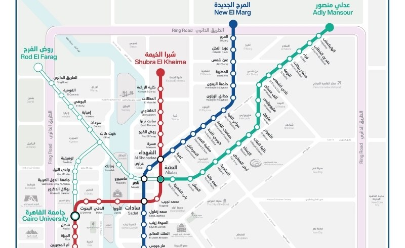
As the diggers keep on digging and the drillers keep on drilling to pave the path for the extension of Cairo’s Green Metro Line 3, mobility company Transport for Cairo (TfC) has unveiled the official map for the underground extension. The map lays out the full network as it penetrates the subterranean maze beneath Zamalek, Imbabah, and all the way towards Rod El Farag.
TfC recognises that navigating a megacity like Cairo is no easy venture, so it works to simplify its multi-modal public transport mishmash. The new map was commissioned by RATP Dev Mobility Cairo (RDMC) - the subsidiary of Paris’ public transport operator, RATP Dev - which will be running Cairo’s Green Line 3 for the next 15 years, and presents the 13 new stations under construction from Central Cairo to Giza.
The extension will see the third line connect from Attaba Station to Nasser Station, running through Maspero, Zamalek, and Kit Kat, where trains will either continue through Sudan, Imbaba, El Bohy, El Qawmia, Ring Road, and Rod El Farag, or head to Tawfikia, Wadi El Nile, Gameat El Diwal El Arabia, Boulak El Dakrour, and Cairo University,
Cairo’s metro network is undergoing substantial extensions as the government invests heavily in its public transportation infrastructure and combat to Cairo’s plague of gridlocked streets, with additional works underway for Metro Line 4, 5, and 6.
Currently carrying an estimated 4 million passengers each day, the Line 3 extension alone is expected to take another million commuters off the roads and into its air-conditioned, metro labyrinth upon completion.
- Previous Article HOW (NOT) TO GO TO A PING PONG SHOW
- Next Article Tilitonse Makes Food That’ll Make You Sing ‘Kumbaya’
Trending This Week
-
Feb 12, 2026


